-
How to get there
It is not possible to drive right up to the Thames Source, i.e. if you want to see it, some walking is necessary. There are several options depending on how close to the source you want to start. One possible starting point for this is the A429 north-east of Kemble.
-
Parking
There's a small lay-by, but otherwise there is no dedicated place to park (normally somewhere along the road should also be fine). Right by the lay-by there's a gate and just beyond you should see an information board. Other than the lay-by, parking in the area is difficult, although near to the railway bridge there also are a couple of parking places. if you plan a refreshment before or after the walk, the local pub up the road might also be a possibility, but please check with the landlord first.
-
Accessibility
Especially when the ground is wet, the area coming up to and around the Thames Source is not suitable for wheels or walking aids which are depended on.
-
Further Information
Wikipedia: http://en.wikipedia.org/wiki/Thames_Head
Telephone: For more information lease contact the National Trails Office on 0044 (0)1865 810224.
The Thames Source pictured walk
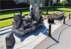
A stone marks the spot beside an old ash tree in a field in Gloucestershire where the River Thames is born. A walk from the main road to the source is well worth spending an hour or so, if just to see where the whole River Thames story begins.
The source is ususally dry for much of the year, and some open land needs negotiating before you get there. Hence one of the best times to go is on a nice day in mid to late spring, when there's a good chance of the ground not being soggy yet still actually seeing some water at the source. Having said that it is also a very nice walk at other times of the year!
View the The Thames Source Pictured Walk
Walking
A number of routes are signposted to the source from the main road the A433. The best marked route takes you along the north-west side of the railway line before crossing over at the designated rail crossing (Take Care!).
The path then leads down over a field to a stone wall and a style. Cross over this and go to the left heading towards the gate in the wall ahead.
Once through this, the source is marked by the stone in the far right hand side of the field. The same route can be taken back or alternatively follow the fields straight back up to the main road and turn right to go back to the starting point.
Depending on when you go, the source of the river may or may not be visible. During dry periods the spring dries up and nothing can be seen for quite a bit, but during periods of wet weather the river can be seen bubbling up from the ground. The drawback, however, is that in the latter case the area can be come quite waterlogged, making acc
General Information


